Landsat 7 for reconstructing the dissapearance of Poopo lake
In December 2015 new published several articles about the disappearance of the Poopo lake, which used to be the second biggest Bolivian lake. There is still uncertainty about the causes that dried the Poopo lake out.
Local residents claim that mining activities and erroneous water policies are the causes that dried the lake out. Local government prefers the easy solution and blames climate change, despite the fact that climate change is a process that takes several years. This article will not get into the detail of discussing why the lake dried out, but it will apply Landsat 7 data for reconstructing the last 17 years of the lake.
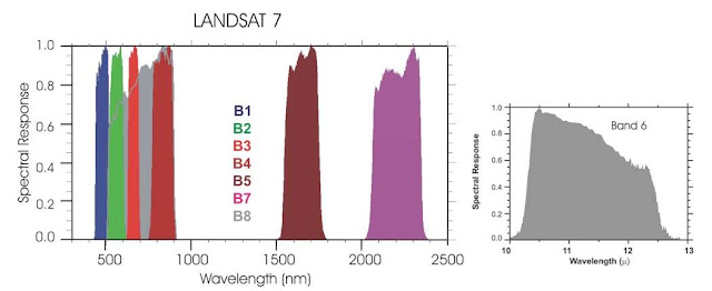
Landsat 7 mission was launched on April 1999, as the seventh satellite of the Landsat programme. It collects and stores 532 multi-spectral and panchromatic images of the Earth per day. It has 7 multi-spectral bands and one panchromatic band (Image 1).
Image 1. Landsat 7 bands
Source (What when how)
The normalized difference of the vegetation index (NDVI) provides a measure of the vegetation amount and condition of vegetation. The pigment in plant leaves, chlorophyll, strongly absorbs visible light (from 0.4 to 0.7 µm) for use in photosynthesis. The cell structure of the leaves, on the other hand, strongly reflects near-infrared light (from 0.7 to 1.1 µm). The more leaves a plant has, the more these wavelengths of light are affected, respectively. Thus, NDVI is estimated by a non-linear transformation of the visible (VIS) and near-infrared (NIR) bands of satellite information.
NDVI = (NIR - VIS) / (NIR + VIS)
If there is much more reflected radiation in near-infrared wavelengths than in visible wavelengths (High NDVI), then the vegetation in that pixel is likely to be dense and may contain some type of forest. On the other hand, if there is very little difference in the intensity of visible and near-infrared wavelengths reflected (Low NDVI), then the vegetation is probably sparse and may consist of grassland, tundra, or desert (Image 2). Water bodies are the opposite of vegetation because they reflect more visible energy than infrared energy; hence, water yields zero and negative NDVI values.

Image 2. NDVI concept
Source: Earthobservatory
For this post we used Landsat 7 images from the Poopo lake area collected within the months of July - September (clear skies) between the year 2000 and the year 2016. NDVI was estimated for each image; thus, it was possible to estimate yearly extension of the Poopo lake. The video of the link and the GIF animation show an animation of the last 17 years of the Poopo lake. After 2013 the lake experienced an accelerated retreat that ended in its disappearance.
The disappearance of Poopo Lake had serious socio - economic - environmental consequences. Local people had to migrate to other location, and the ecosystem of the region was destroyed. There are several doubts whether it will be possible to recover the ecosystem or not. The damage is done and it is urgent to look for recovery / adaptation policies. Unfortunately, bolivian government focuses on blaming others instead of acting.
The disappearance of Poopo Lake had serious socio - economic - environmental consequences. Local people had to migrate to other location, and the ecosystem of the region was destroyed. There are several doubts whether it will be possible to recover the ecosystem or not. The damage is done and it is urgent to look for recovery / adaptation policies. Unfortunately, bolivian government focuses on blaming others instead of acting.
Animation 1. Poopo lake drying out 2000 - 2016 (based on Landsat 7 data)


No comments
Post a Comment